The Mississippi River

The Mississippi River is the largest river system in North America.About 2,320 miles (3,730 km) long, the river originates at Lake Itasca, Minnesota, and flows slowly southwards in sweeping meanders, terminating 95 miles (153 km).

The Amazon River

The Amazon River of South America is the second longest river in the world with an average discharge greater than the next seven largest rivers combined.

The Kapuas River

The Kapuas River is a river in the Indonesian part of Borneo island, at the geographic center of Maritime Southeast Asia. At 1,143 kilometers in length, it is the longest river of Indonesia and one of the world's longest island rivers.

The Ganges River

The Ganges or Ganga,is a trans-boundary river of India and Bangladesh.The 2,525 km (1,569 mi) river rises in the western Himalayas in the Indian state of Uttarakhand.

The Yangtze River

The Yangtze is the longest river in Asia, and the third-longest in the world. It flows for 6,418 kilometres from the glaciers on the Tibetan Plateau in Qinghai eastward across southwest,central and eastern China before emptying into the East China Sea at Shanghai.

Showing posts with label History of Amazon. Show all posts

Friday, June 10, 2011

Dispute Regarding Length of Amazon

While debate as to whether the Amazon or the Nile is the world's longest river has gone on for many years, the historic consensus of geographic authorities has been to regard the Amazon as the second longest river in the world, with the Nile being the longest. However, the Amazon has been measured by different geographers as being anywhere between 6,259 and 6,800 kilometres (3,889 and 4,200 mi) long. It is often said to be "at least" 6,400 kilometres (4,000 mi) long. The Nile is reported to be anywhere from 5,499 to 6,690 kilometres (3,417 to 4,160 mi). Often it is said to be "about" 6,650 kilometres (4,130 mi) long. There are many factors that can affect these measurements.
A study by Brazilian scientists concluded that the Amazon is actually longer than the Nile. Using Nevado Mismi, which in 2001 was labeled by the National Geographic Society as the Amazon's source, these scientists made new calculations of the Amazon's length. They calculated the Amazon's length as 6,992 kilometres (4,345 mi). Using the same techniques they calculated the length of the Nile as 6,853 kilometres (4,258 mi), which is longer than previous estimates but still shorter than the Amazon. They made it possible by measuring the Amazon downstream to the beginning of the tidal estuary of Canal do Sul and then, after a sharp turn back, following tidal canals surrounding the isle of Marajó and finally including the marine Waters of the Río Pará bay in its entire length. Guido Gelli, director of science at the Brazilian Institute of Geography and Statistics (IBGE), told the Brazilian TV network Globo in June 2007 that it could be considered as a fact that the Amazon was the longest river in the world. However, other geographers have had access to the same data since 2001, and a consensus has yet to emerge to support the claims of these Brazilian scientists. As of 2010 the length of both the Amazon and the Nile remains open to interpretation and continued debate.

20th and 21st Century Concerns of Amazon

http://upload.wikimedia.org/wikipedia/commons/thumb/9/94/Manaus-Amazon-NASA.jpg/220px-Manaus-Amazon-NASA.jpgFour centuries after the European discovery of the Amazon river, the total cultivated area in its basin was probably less than 65 square kilometres (25 sq mi), excluding the limited and crudely cultivated areas among the mountains at its extreme headwaters. This situation changed dramatically during the 20th century.
Wary of foreign exploitation of the nation's resources, Brazilian governments in the 1940s set out to develop the interior, away from the seaboard, where foreigners owned large tracts of land. The original architect of this expansion was President Getúlio Vargas, with the demand for rubber from the Allied forces in World War II providing funding for the drive.
In 1960, the construction of the new capital city of Brasília in the interior also contributed to the opening up of the Amazon Basin. A large-scale colonization program saw families from Northeastern Brazil relocated to the forests, encouraged by promises of cheap land. Many settlements grew along the road from Brasilia to Belém, but rainforest soil proved difficult to cultivate.
Still, long-term development plans continued. Roads were cut through the forests, and in 1970, the work on the Trans-Amazonian highway (Transamazônica) network began. The network's three pioneering highways were completed within ten years, but never fulfilled their promise. Large portions of the Trans-Amazonian and its accessory roads, such as BR-319 (Manaus-Porto Velho), are derelict and impassable in the rainy season. Small towns and villages are scattered across the forest and because its vegetation is so dense, some remote areas are still unexplored.
With a current population of 1.8 million people, Manaus is the Amazon’s largest city. Manaus alone represents approximately 50% of the population of the Brazilian state of Amazonas, which is the largest state. The racial makeup of the city is 64% Pardo (Mulatto and mestizo) and 32% White.

Post-Colonial History of Amazon

http://upload.wikimedia.org/wikipedia/commons/thumb/d/dd/Naturalist_on_the_River_Amazons_figure_32.png/170px-Naturalist_on_the_River_Amazons_figure_32.pngOn 6 September 1850 the emperor, Pedro II, sanctioned a law authorizing steam navigation on the Amazon, and gave the Viscount of Mauá (Irineu Evangelista de Sousa) the task of putting it into effect. He organized the "Companhia de Navegação e Comércio do Amazonas" in Rio de Janeiro in 1852; and in the following year it commenced operations with three small steamers, the Monarch, the Marajó and Rio Negro.
At first, navigation was principally confined to the main river; and even in 1857 a modification of the government contract only obliged the company to a monthly service between Pará and Manaus, with steamers of 200 tons cargo capacity, a second line to make six round voyages a year between Manaus and Tabatinga, and a third, two trips a month between Pará and Cametá. This was the first step in opening up the vast interior.
The success of the venture called attention to the opportunities for economic exploitation of the Amazon, and a second company soon opened commerce on the Madeira, Purus and Negro; a third established a line between Pará and Manaus; and a fourth found it profitable to navigate some of the smaller streams. In that same period, the Amazonas Company was increasing its fleet. Meanwhile, private individuals were building and running small steam craft of their own on the main river as well as on many of its tributaries.
On 31 July 1867 the government of Brazil, constantly pressed by the maritime powers and by the countries encircling the upper Amazon basin, especially Peru, decreed the opening of the Amazon to all flags; but limited this to certain defined points: Tabatinga – on the Amazon; Cametá – on the Tocantins; Santarém – on the Tapajós; Borba – on the Madeira, and Manaus – on the Rio Negro. The Brazilian decree took effect on 7 September 1867.
Thanks in part to the mercantile development associated with steamboat navigation, coupled with the internationally driven demand for natural rubber (1880–1920), Manáos (now Manaus) and Pará (now Belém) in (Brazil), and Iquitos, Peru became thriving, cosmopolitan centers of commerce and spectacular—albeit illusory—"modern" "urban growth". This was particularly the case for Iquitos during its late 19th and early 20th century Rubber Bonanza zenith when this dynamic boomtown was known abroad as the St. Louis of the Amazon. Foreign companies settled in this city, from where they controlled the extraction of rubber. In 1851 Iquitos had a population of 200 and by 1900 its population reached 20,000. In the 1860s, approximately 3,000 tons of rubber was being exported annually and by 1911 annual exports had grown to 44,000 tons, representing 9.3% of Peru’s exports. During the rubber boom it is estimated that diseases brought by immigrants such as typhus or malaria killed 40,000 native Amazonians.
The first direct foreign trade with Manaus was commenced around 1874. Local trade along the river was carried on by the English successors to the Amazonas Company—the Amazon Steam Navigation Company—as well as numerous small steamboats, belonging to companies and firms engaged in the rubber trade, navigating the Negro, Madeira, Purus and many other tributaries, such as the Marañón to ports as distant as Nauta, Peru. The Amazon Steam Navigation Company had 38 vessels.
By the turn of the 20th century, the principal exports of the Amazon Basin were India-rubber, cacao beans, Brazil nuts and a few other products of minor importance, such as pelts and exotic forest produce (resins, barks, woven hammocks, prized bird feathers, live animals, etc.) and extracted goods (lumber, gold, etc.).

Colonial Encounters of Amazon

http://upload.wikimedia.org/wikipedia/commons/thumb/c/c9/Indios_munduruku.jpg/220px-Indios_munduruku.jpgDuring what many archaeologists call the formative period, Amazonian societies were deeply involved in the emergence of South America's highland agrarian systems, and possibly contributed directly to the social and religious fabric constitutive of the Andean civilizational orders.
In 1500, Vicente Yáñez Pinzón was the first European to sail into the river. Pinzón called the river flow Río Santa María del Mar Dulce, later shortened to Mar Dulce (literally, sweet sea, because of its freshwater pushing out into the ocean). For 350 years after the first European encounter of the Amazon by Pinzón, the Portuguese portion of the basin remained an untended former food gathering and planned agricultural landscape occupied by the indigenous peoples who survived the arrival of European diseases. There is ample evidence for complex large-scale, pre-Columbian social formations, including chiefdoms, in many areas of Amazonia (particularly the inter-fluvial regions) and even large towns and cities. 
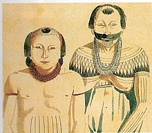
For instance the pre-Columbian culture on the island of Marajó may have developed social stratification and supported a population of 100,000 people. The Native Americans of the Amazon rain forest may have used Terra preta to make the land suitable for the large scale agriculture needed to support large populations and complex social formations such as chiefdoms.
One of Gonzalo Pizarro's lieutenants, Francisco de Orellana, set off in 1541 to explore east of Quito into the South American interior in search of El Dorado and the "Country of Cinnamon". He was ordered to follow the Coca River and return when the river reached its confluence. After 170 km, the Coca River joined the Napo River (at a point now known as Puerto Francisco de Orellana), and his men threatened to mutiny if he followed his orders and the expedition turned back. On 26 December 1541, he accepted to change the purpose of the expedition to the conquest of new lands in the name of the King of Spain, and the 49 men built a larger boat in which to navigate downstream. After a journey of 600 km down the Napo River, constantly threatened by the Omaguas, they reached a further major confluence, at a point near modern Iquitos, and then followed what is now known as the Amazon River for a further 1200 km to its confluence with the Rio Negro (near modern Manaus), which they reached on 3 June 1542. This area around the Amazon was dominated by the Icamiaba natives, who were mistaken for fierce female warriors by the members of the expedition. Orellana later narrated the belligerent victory of the Icamiaba “women” over the Spanish invaders to Charles V, Holy Roman Emperor, who, recalling the Amazons of Greek mythology, baptized the river Amazonas, the name by which it is still known in both Spanish and Portuguese. At the time, however, the river was referred to by the expedition as Grande Río ("Great River"), Mar Dulce ("Freshwater Sea") or Río de la Canela ("Cinnamon River"). Orellana claimed that he had found great cinnamon trees there, in other words a source of one of the most important spices reaching Europe from the East. In fact, true cinnamon (Cinnamomum verum) is not native to South America. Other related cinnamon-containing plants (of the family Lauraceae) do occur and Orellana must have observed some of these. The expedition continued a further 1200 km to the mouth of the Amazon, which it reached on 24 August 1542, demonstrating the practical navigability of the Great River. This was surely one of the most improbably successful voyages in known history.
In 1560 another Spanish conquistador, Lope de Aguirre, made the second descent of the Amazon.
In 1637–47 the Portuguese explorer Pedro Teixeira was the first European to ascend the river from Belém, near the mouth, to Quito, part of the Spanish Viceroyalty of Peru, and then to return the same way. Teixeira's expedition was massive—some 2000 people in 37 large canoes. From 1648 to 1652, António Raposo Tavares lead one of the longest known expeditions from São Paulo to the mouth of the Amazon, investigating many of its tributaries, including the Rio Negro, and covering a distance of more than 10,000 km (6,214 mi).
In what is currently Brazil, Ecuador, Bolivia, Colombia, Peru, and Venezuela, a number of colonial and religious settlements were established along the banks of primary rivers and tributaries for the purpose of trade, slaving and evangelization among the indigenous peoples of the vast rain forest, such as the Urarina. Father Fritz, apostle of the Omaguas, established some forty mission villages. Charles Marie de La Condamine accomplished the first scientific exploration of the Amazon River.
Many indigenous tribes engaged in constant warfare. According to James Stuart Olson, "The Munduruku expansion dislocated and displaced the Kawahib, breaking the tribe down into much smaller groups... [Munduruku] first came to the attention of Europeans in 1770 when they began a series of widespread attacks on Brazilian settlements along the Amazon River."
The Cabanagem, one of the bloodiest regional wars ever in Brazil, which was chiefly directed against the white ruling class, reduced the population of Pará from about 100,000 to 60,000.
The total population of the Brazilian portion of the Amazon Basin in 1850 was perhaps 300,000, of whom about two-thirds comprised by Europeans and slaves, the slaves amounting to about 25,000. The Brazilian Amazon's principal commercial city, Pará (now Belém), had from 10,000 to 12,000 inhabitants, including slaves. The town of Manáos, now Manaus, at the mouth of the Rio Negro, had a population between 1,000 to 1,500. All the remaining villages, as far up as Tabatinga, on the Brazilian frontier of Peru, were relatively small.